
Nearly 20,000 U.S. public elementary and middle schools sit within a quarter-mile of crop fields where harmful pesticides may be sprayed, a new EWG analysis finds. Almost 7 million students attend those schools and could be exposed, including more than 575,000 at schools within 200 feet of a field.
Pesticide applications could be putting children, families and school staff at risk because they lack basic protections such as buffer zones and warnings.
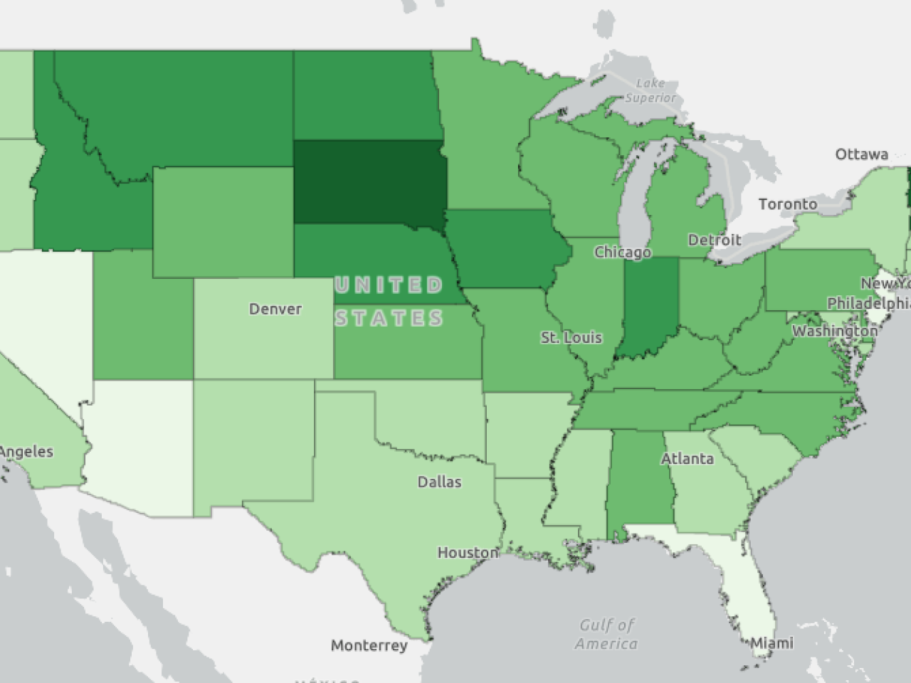
This map shows the number and percentage of elementary and middle schools within a quarter mile, 1,000 feet and 200 feet of what the Department of Agriculture considers to be a crop field. These schools have the potential to be in the “spray zone” of pesticides that may be used on these fields. Pesticides sprayed on crop land can harm children who attend schools nearby.
Children face higher risks of the potential health harms linked to pesticides because their developing bodies and nervous systems are more vulnerable to chemical toxicity. Two hundred feet is close enough for harmful drift to reach classrooms and playgrounds. In addition to students, thousands of teachers and other school staff are at risk.
EWG’s new map allows users to see how many schools in their state, county, congressional district or state legislative district are at risk. It does not account for public high schools or private schools. Nor does it include the thousands of public parks, playgrounds and ball fields where children live and play that may also be sprayed with pesticides. Schools were considered if they contained at least one grade that is K-8.
Research shows that pesticides are often detected inside homes as far as a half-mile from spraying. EWG found 1,932 public elementary and middle schools within just 200 feet of application and 19,208 within a quarter-mile of a crop field that could be treated with pesticides – one out of every four schools in America.
And it doesn’t matter where kids go to school – this is a nationwide issue:
- In New York, over 550 schools are within a quarter-mile of a crop field, totaling over 200,000 students.
- In Ohio, almost 1,000 schools and 400,000 children are within a quarter-mile of a crop field.
- In Florida, over 270 schools and almost 150,000 children.
- In Colorado, 340 schools and over 100,000 children.
- In Vermont, more than 71% of schools in the state are within a quarter-mile of a crop field.
But families lack key information about these commercial pesticide applications. Parents and caregivers deserve the certainty of knowing their children are not being exposed to harmful pesticides when they are at school. They have the right to know when pesticides are being applied near their schools, who is applying them, what is being applied and what precautions are being taken to protect children.
EWG’s map makes it clear that Congress must do more to protect consumers and kids at schools from commercial applications of toxic chemicals.
That’s why EWG and Consumer Reports are urging Congress to reject any new pesticide laws unless they include the Consumer Pesticide Safety Bill of Rights – a road map for making the food Americans eat and the communities they live in safer. It addresses long-running gaps in pesticide protection, and it includes a call for Congress to ensure that children are safe from pesticide exposure while at school.
What are the health risks of pesticide exposure?
Studies show that living near pesticide spraying is linked to harm to the respiratory system, increased risk of cancer and harm to the developing fetus, such as low birth weight and reduced IQ.
According to the American Academy of Pediatrics, children are especially susceptible to potential health problems stemming from pesticide exposure, such as neurological and behavioral development, endocrine disruption and cancer.
Spraying creates dangers not just for kids at schools close to fields where pesticides are used but also for those in more distant neighborhoods, where chemicals may drift.
Pesticide air monitoring has shown some pesticides can travel miles from the application site. Evidence suggests health harms such as pediatric cancers may be associated with pesticide applications up to 2.5 miles away.
How is pesticide use regulated near schools?
Many states, cities and counties have adopted legal standards to restrict pesticide spraying near schools, citing the risks it poses to children, whose bodies and brains are still developing. But these protections vary from state to state.
More than 40 states – including Georgia, Illinois, New York, North Carolina and Texas – have restricted how and when pesticides can be sprayed near schools.
Alabama and North Carolina, for example, ban crop dusting near schools. Many other states – including Arizona, Louisiana, Maine, Michigan and New Hampshire – have placed buffer zones that restrict pesticide spraying around schools.
Illinois and other states require that alerts be posted on school grounds to tell students before or after spraying.
Some states, including Kentucky, Minnesota and Nevada, require that parents be notified. Others, like Louisiana and Pennsylvania, require schools to track students who are sensitive to pesticides.
Other states, including Georgia and New Mexico, limit the hours when pesticides can be sprayed near schools. California prohibits pesticide applications within a quarter-mile of public schools during the hours when children are most likely to be present. The state also requires additional notifications, reporting and training,
What should the Environmental Protection Agency and Congress do?
State regulations and laws are inconsistent, and many help parents and students only after they have been exposed to toxic chemicals or when it is too late.
The standards also always assume pesticides will be applied without error by the applicator – something that isn’t always done.
Instead, the federal government should set a minimum standard for buffer zones around schools, and ensure states’ ability to go further. Even though the people who spread the chemicals on farm fields may already be required to wear special protective gear, communities nearby remain unprotected.
Congress and the EPA can also ensure proper notifications are sent if pesticides are applied near schools, as many states already require.
Parents and families should not have to track down a government registry, pay a fee or require a doctor’s note to be notified of pesticide applications that could expose them, their children or their pets to toxics. Families deserve to know whether someone living or working near their home has applied pesticides that can make people sick.
As with some state programs, the EPA and states should work together to proactively notify people of commercial pesticide applications near their homes and schools. This would give parents more information to potentially lower their kids’ exposure risk.
Pesticide companies, including Bayer’s Monsanto and ChemChina’s Syngenta, are actively trying to hide pesticide application information from consumers. These companies are trying to boost pesticide sales and hide the risks from industrial chemical use.
Now, they’re trying to push Congress to quickly reauthorize a pesticide law, the Pesticide Registration Improvement Act, without making any changes to protect the public.
Congress might consider renewing the Pesticide Registration Improvement Act as early as December. The current law, through which the chemical industry negotiates fees that fund the EPA’s pesticide reviews, is set to expire next September.
Lawmakers shouldn’t support any new pesticide law that fails to protect consumers and kids at school. Any such legislation should adopt EWG and Consumer Reports’ Consumer Pesticide Safety Bill of Rights – making clear that consumers deserve to be protected from toxic chemicals.